The original maps of Titan are being updated and revised by the Titan Rebuilding forum members and drawn up by Mr Nibbs. This is a collection point for map data and relevant discussions.
Saturday, 7 May 2011
Thursday, 5 May 2011
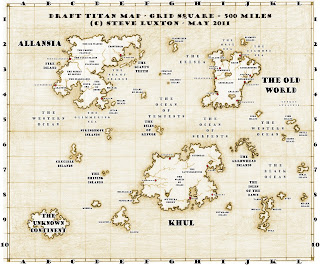
Titan Map v6
These latest tweaks to the draft Titan map means we can now make an index of locations with grid references. On the first map only the grid has been moved slightly to the right to improve the visual balance. No other maps use this new grid yet, so don't use it for plotting anything onto.
The latest blank map.
Is it just me, or does the unknown continent look like Amarillia the wrong way round?
The climate map with revised text
Tuesday, 3 May 2011
New Map of Titan
Here's the grid reference system. It's kept really simple so you don't need any map-reading skills to read it. Grid squares are named A1 to L10, which can also be used to refer to other maps showing greater detail. These maps will probably be part of a resource book for gamebook authors and players, so don't expect contemporary mapping. It really a design for a board game based on old naval charts.
This world map is a "how to get from A to B safely" document. It need only mark the ports and largest cities on the lands masses. This map contains most of the labelling on the original Titan map already, but there's more to be added.
This is the base map on which information layers are added. A text layer usually comes first because clarity and legibility are extremely important. Other layers will use small graphics, colour and texture to add different types of information with more detail.
Translators: please note how the text for "The Old World" obscures the x showing the location of Atlantis, which will be moved further south later.
More info from the original maps will be added to the world and Allansia maps. To complete the base maps we need to decide on...
1. A list of the settlements that should go on each map, graded into small, medium, and large settlements.
2. Any given heights above sea level for important locations.
3. Any other relevant information to these two draft maps.
... and to explore any suggestions, comments, observations and questions you might like to post here.
This world map is a "how to get from A to B safely" document. It need only mark the ports and largest cities on the lands masses. This map contains most of the labelling on the original Titan map already, but there's more to be added.
Translators: please note how the text for "The Old World" obscures the x showing the location of Atlantis, which will be moved further south later.
More info from the original maps will be added to the world and Allansia maps. To complete the base maps we need to decide on...
1. A list of the settlements that should go on each map, graded into small, medium, and large settlements.
2. Any given heights above sea level for important locations.
3. Any other relevant information to these two draft maps.
... and to explore any suggestions, comments, observations and questions you might like to post here.
Subscribe to:
Comments (Atom)


